Weather
TD Luis slightly intensifies; Signal No. 1 up over parts of Bicol, Polillo Islands
Tropical Depression Luis slightly intensified early Sunday as it moved slowly over the Philippine Sea east of the Bicol Region, prompting the Philippine Atmospheric, Geophysical and Astronomical Services Administration (
6K reads
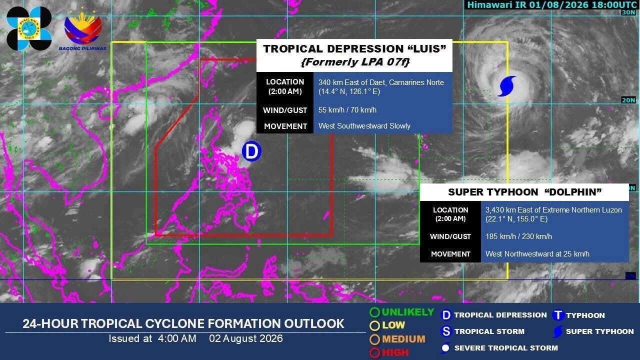
Tropical Depression Luis slightly intensified early Sunday as it moved slowly over the Philippine Sea east of the Bicol Region, prompting the Philippine Atmospheric, Geophysical and Astronomical Services Administration (PAGASA) to maintain Tropical Cyclone Wind Signal (TCWS) No. 1 over parts of Luzon.
In its 5 a.m. tropical cyclone bulletin, PAGASA said the center of Luis was estimated at 4 a.m. at 295 kilometers east of Daet, Camarines Norte.
The tropical depression packed maximum sustained winds of 55 kilometers per hour (kph) near the center, gusts of up to 70 kph, and a central pressure of 1,002 hectopascals. It was moving west southwestward slowly.
TCWS No. 1 remains in effect over the Polillo Islands, Camarines Norte, Catanduanes, and the northern portion of Camarines Sur, including Caramoan, Presentacion, Garchitorena, Lagonoy, Tinambac, Siruma, Goa, San Jose, Tigaon, and Calabanga.
Under Signal No. 1, areas may experience winds of 39 to 61 kph within 36 hours, posing a minimal to minor threat to life and property.
PAGASA said the possibility of raising Signal No. 2 has not been ruled out.
The weather bureau advised the public to monitor its heavy rainfall advisories, warning that Luis and the southwest monsoon could bring moderate to heavy rains that may trigger flash floods and landslides in vulnerable areas.
Aside from the wind signal areas, the southwest monsoon and the outer circulation of Luis are expected to bring strong to gale-force gusts on Sunday over Marinduque, the southern portion of Mindoro provinces, Romblon, mainland Masbate, the Caluya Islands, Siquijor, Southern Leyte, Camiguin, and Dinagat Islands.
By Monday and Tuesday, these gusty conditions may affect most of Luzon and the Visayas, as well as Lanao del Norte, Misamis Occidental, Camiguin, Surigao del Norte, Dinagat Islands, Davao Occidental, and Davao Oriental.
PAGASA also warned of moderate to rough seas over the eastern seaboard of Davao Oriental, where waves may reach up to 2.5 meters, and up to 2 meters along the province's southern coast and the southeastern seaboard of Davao Occidental. Mariners of small vessels were advised to exercise caution or avoid sailing if possible.
Luis is forecast to continue moving slowly westward to west northwestward over the next 36 hours before turning north northeastward.
While the tropical depression is expected to remain over the Philippine Sea, PAGASA said a westward shift in its track could result in a landfall or close approach to Northern or Central Luzon.
Luis is forecast to intensify into a tropical storm within the next 24 hours while east of the Bicol Region before weakening as it turns northeastward. It may weaken into a remnant low by Wednesday and eventually be absorbed by the circulation of Super Typhoon Dolphin, PAGASA said.
The sun rose at 5:40 a.m. Sunday and will set at 6:25 p.m. — MCG GMA News
Share